
By
George S. Pearl
In many cases, a scale drawn map or aerial
photograph can be a vital part of the presentation. Sometimes a case may
not warrant the expense of professional exhibits, but in those cases the
attorney can still provide some type of demonstrative aid to show the lay
of the land, direction of travel, timing or location of witnesses. Even
simple lines drawn on a sketch pad with the aid of a marker and yardstick
can be drawn to scale for better understanding.
The word ”scale” used throughout this article should be burned
into your subconscious so you will consider all of your maps, diagrams and
vertical aerial photographs in some measurable scale. False conclusions
can be drawn from inaccurate sketches by the witnesses, the attorneys, and
the jury. The posture of many cases completely changes when a scale drawing
or a scale aerial photograph is produced.
Generally, a traffic accident report is not a reliable aid
to understand an accident scene. When it says ”not to scale”
on the report, they aren’t kidding... even directions may be incorrect.
Actual D.O.T. engineered drawings of roadways are seldom found to be what
was actually constructed.
There are a number of ways to illustrate an accident scene.
The first is a scale-drawn map prepared for use in court. This is not the
same as a map as produced by a surveyor or engineer. Maps and diagrams for
court proceedings are more graphic and much simpler than a complicated engineering
drawing. Maps used in court should be large enough for every juror to easily
read them. Sometimes the exhibit size, due to its scale and what needs to
be demonstrated, will be large. Even large exhibits, though, can be completely
hidden. The exhibit should be simple enough for any juror to quickly grasp
the story. Maps should be marked so that jurors can easily follow them.
The use of color on maps is common, and magnetic moveable parts are a great
asset. Green grass, the direction to downtown and building locations can
serve as orientation aids for the viewer.
Maps should be produced with your witnesses’ input. After
all, they will be testifying and the map should serve as a visual aid to
their testimony. A demonstrative evidence expert should be relied upon to
produce the proper exhibit to match the case once the needs of the person
testifying are explained. There are many specialized firms throughout the
country that produce court exhibits and are members of the professional
non-profit organization known as ”DESA” (Demonstrative Evidence
Specialists Association). To be directed to a DESA member nearest your location,
call the Association’s office at 1-800-552-DESA.
Scale drawn maps and diagrams may take on many variations, and I call one
of my own variations the aerial photo-map. This type of exhibit is produced
by first reducing a precision vertical aerial photograph to the needed scale,
then care- fully removing all the unwanted vehicles from the scene.
The precision vertical scale aerial photograph can be of tremendous
value in proving your case. Everything is captured in the scene. Sometimes
unique features are seen in the aerial view that cannot be seen on the ground.
In a recent case concerning a pedestrian wrongful death action, the aerial
photograph showed how the curb line had been moved back, producing an unplanned
turn lane, disrupting the natural direction of the pedestrian crosswalk.
This vital knowledge would not have been discovered without the aerial view.
Scale and vertical aerial maps can be used to demonstrate timing with the
known vehicle speeds converted into magnetic moveable rules that show the
measurement of distances in seconds to impact. This allows for a quick understanding
of speed versus distance.
Diagrams are similar to maps but are generally used for floor
plans and interior locations. Diagrams of walkways and stairways can be
produced to scale to demonstrate how they were not built to code requirements.
A diagram should be graphic to promote interest and to help delineate areas
of importance. Scale is still important for the viewer to relate objects
and areas to distance and time.
The production of a scale drawn map or diagram may take several weeks to
complete. Depending upon the area to be measured and the detail required,
the basic measurement process alone can take a long time. Curves in the
road, for example, take a tremendous amount of time to accurately measure.
Both traffic and weather can cause difficulty in the production of an accurate
map. Unfortunately, attorneys sometimes delay the exhibit creation so long
the entire accident scene changes. Recreating a scene under those circumstances
can be very expensive. One significant feature a map should demonstrate
is the grade of the roadway, which can be very important if there are hills.
If the truck driver says that he lost his brakes coming down a steep hill
before the intersection, you may want to show the jury how steep the hill
was. The percentage of the grade of a road is measured at several points
along the road and then matched with the map view so that one can easily
see how steep the slope of the road is at any location. If driver sight
lines are blocked because of hills, magnetic scale model vehicles can be
made with fluorescent lines running from one driver eye level to the other
to act as an ”automatic sight lines.” When this type of display
is used, any number of different distances can be shown approaching the
crest of a hill with the sight lines of the drivers always being displayed.
This demonstrates whether the drivers could see one another at any of the
positions at issue.
Do not think of charts and aerials as simply for trial use. When they are
prepared early in the case you get more for your money because of the better
understanding you and the witnesses gain from viewing the exhibits.
Maps and diagrams can be taken one step further into the actual animation
of the magnetic vehicles with filming or by inputting the map into a computer
and then animating its parts. A future article will appear on animation;
until then, map out your case.
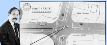
James
Goldstein demonstrates an intersection collision with a precision vertical
aerial map.
(See Clary v. Miller, et. al. in the March / April 1991 issue of The Verdict,
page 27.)
George Pearl, President of Atlanta based ALPS Evidence & Photo, is a certified evidence photographer and a fellow of the Evidence Photographers International Council and Certified Professional Photographer of the Professional Photographer of America. He is a Certified Questioned Document Examiner and Handwriting Expert with the Association of Forensic Document Examiners. He also serves as a board member of the Demonstrative Evidence Specialist Association dedicated to maintaining the highest standards in the production of demonstrative evidence.
* This article was first published in THE VERDICT of July / August of 1991.
© Atlanta Legal Photo Services, Inc.